A system for the location and information of trenches and underground pipelines
With digitized document management

Trenchip is an integrated system that allows you to mark, accurately locate and record information about specific points in trenches and underground conduits.
With Trenchip you can view and keep updated information about your infrastructures from anywhere using an application and a Geographic Information System in the cloud.
Your data in the cloud for a further reliable control
With Trenchip data about your infrastructures is sent and processed in the cloud, instead of being stored in the sensor. By accessing the data reported through the web and mobile app, you have control at all times over the information linked to the sensors and can make decisions based on updated data, as well as ensure the security of information on your infrastructure.
The Trenchip system is composed of three main elements:

RFID sensor
It enables the labelling of the points in situ and their subsequent precise location from the surface, for a safer excavation.

Cloud application
The Trenchip cloud software processes the reported data and executes the mapping of all its sensors.

Web and mobile app
It enables to record information about the marked installations, check, update it and visualize all its sensors on the map.
A solution with high added value
Trenchip is a comprehensive system inspired by the concept of the Internet of Things (IoT) with the best available technologies to offer high value-added solutions.
With Trenchip, the control and maintenance of ditches and underground conduits is easier, safer, faster and much cheaper.

Galileo Masters Catalonia 2020 Awards
Winning project in the Galileo Satellite category at the Galileo Masters Catalonia Challenge 2020.
Long-term passive sensors
Trenchip is a technology of very high durability (exceeds 30 years) as it is totally passive, to adapt to the times required in infrastructures.
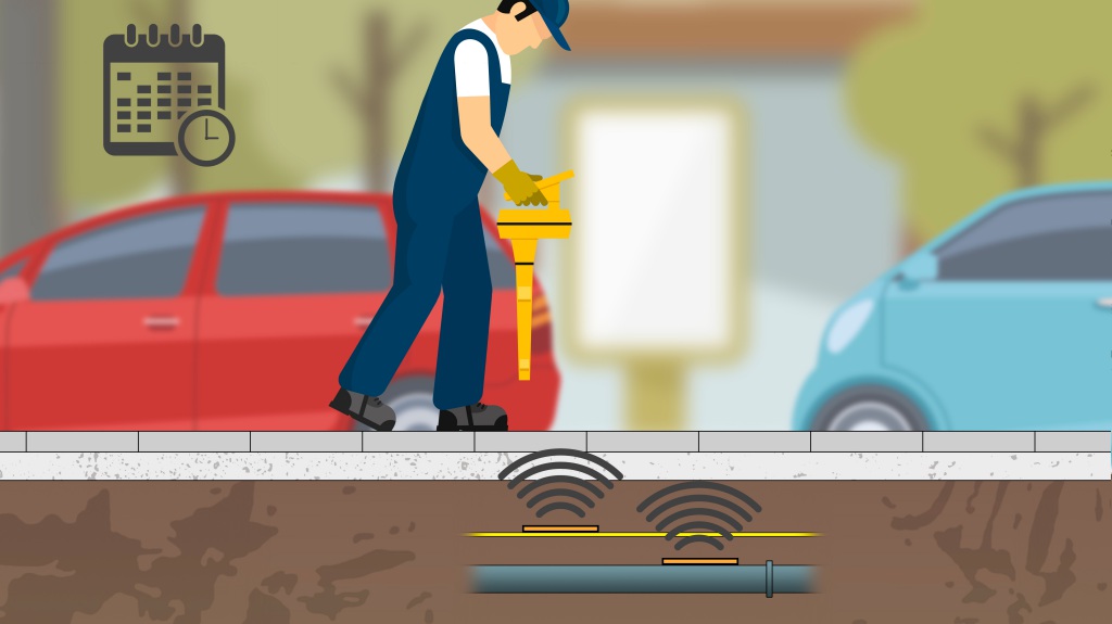
Accurate location of THE SENSORS
The Trenchip sensors incorporate theDetect-Tube, RFID band technology, which allows accurate location of the sensor from the surface employing a high-performance reading device, for safer digging.
GIS integration
A Geographic Information System (GIS) is part of the Trenchip software, which allows you to visualize all your sensors on the map and access the datasheet of each sensor through the app.
IN SITU VISUALISATION WITH AUGMENTED REALITY
The augmented reality function of the mobile app allows you to create and visualise a virtual representation of the underground installation layout, as well as to take 3D images of manholes and key points.
UPDATED DATA
When installing a Trenchip sensor, the data reported through the mobile app is incorporated into the database in the cloud and can be edited later.
integrable on demand
Trenchip can store the data in its own cloud, or be integrated on-demand in the system of the management company.
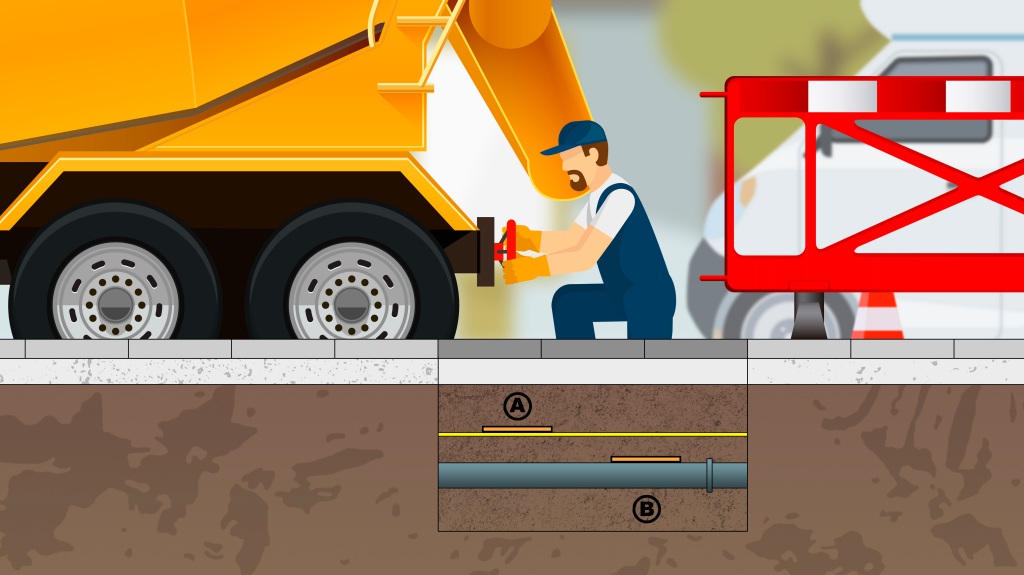
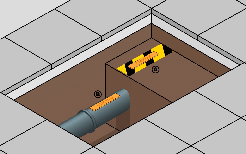
TRENCHIP allows marking and identification of trenches and underground pipes up to 110cm deepwith an accuracy of <10 cm (verified in real conditions).
Trenchip implementation
Sensor placement
Trenchip sensors are very easy to place in ditches and pipes. Directly in the trench, on the pipeline or on the indicator band, as appropriate. A self-adhesive band makes it easy to fix the sensor at the desired point.
Information input
Through the Trenchip app, the operator or person responsible for the intervention records the location of the sensor, as well as the appropriate data. In the Trenchip database you can enter any information about the infrastructure or the installation that has been marked with the sensor: nature, characteristics, effects, owner, adjudicators, installation date, last inspection … Trenchip is highly flexible and allows customization of the fields. With the augmented reality function it is possible to take 3D images of manholes and other infrastructure elements using a simple point image scanning system to facilitate remote inspection.
Data processing, mapping and updating
Trenchip’s software integrates a Geographic Information System (GIS) that allows the location of sensors and underground pipeline routes to be represented on a digitised map. On the Trenchip platform, it is possible to consult the map and interact to access the information that has been incorporated into the sensors and routes.
In addition, the augmented reality function allows 3D images to be captured in the field using a simple point image scanning system, so that elements of the infrastructure can be viewed remotely in 3D for analysis and detailed observation from any angle.
Accurate location of the sensors
The Trenchip mapping system records the GPS coordinates of the sensor location. For successive interventions in a marked installation, operators will be able to precisely locate the pipe or the indicator band using the Trenchip reader device thanks to RFID technology. This will indicate the exact position and depth of the sensor, for a faster and safer intervention.

Visualisation of infrastructures in situ with augmented reality
Trenchip’s augmented reality feature generates a virtual representation of the underground assets and overlays it on top of the image of the real environment, making it easy to visualise and follow the layout of the facilities on the ground. On top of the augmented reality image it is possible to manage and update the map grid data based on the precise location, as well as make corrections to existing utility maps, with high-precision localisation.
With Galileo, 100% accurate location
The Trenchip reader’s GNSS receiver, developed by Witeklab, combines the signals from the European Galileo system and those of other fleets of positioning satellites currently in operation, with terrestrial coverage receivers in most territories.
Using noise reduction algorithms, atmospheric dispersive effects, and Doppler error correction, it achieves greater accuracy than other systems, ensuring accurate sensor detection.
.
Trenchip provides you with effective control of your infrastructure…
Optical fiber
Street lighting
Electricity (MT, BT)
Natural gas
Sewerage
Drinking water
Canalization and rainwater deposits
Irrigation systems in gardens and golf courses
…
Faster, safer, easier
With Trenchip it is possible to carry out maintenance and new installations in the subsoil efficiently and safely, preserving the existing underground assets, minimizing the risks for the operators and reducing the impact in the area, people and activities.
Due to its characteristics, Trenchip allows quick and efficient management of underground assets, which translates into faster actions with the consequent saving of time and costs.
Less risk for operators
Less disturbance to the surrounding area
Faster interventions
Easy to implement, very short learning curve
Partners

Contact us
For further information or a demonstration of the Trenchip system, do not hesitate to contact us using the form below.